

Conference papers
2023 Response of vegetation indices to drought in western Spain
Quirós, E. and Fragoso-Campón, L.: Response of vegetation indices to drought in western Spain, EGU General Assembly 2023, Vienna, Austria, 24–28 Apr 2023, EGU23-7644, https://doi.org/10.5194/egusphere-egu23-7644, 2023
2019 Una experiencia docente basada en proyecto para la formación en competencias profesionales
Miguel Ángel Martín Tardío. Una experiencia docente basada en proyecto para la formación en competencias profesionales. XXV Jornadas sobre Enseñanza Universitaria de la Informática. Murcia, 2019.
PDF
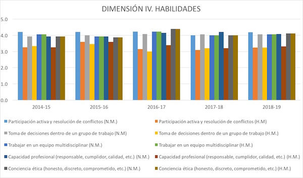
The European Higher Education Area implies that new computer engineers must acquire a series of professional skills. Some learning methodologies such as project-based learning (PBL) help develop these capabilities. This work presents a teaching experience developed with PBL during the last 5 years inthe Computer Engineering degree. While the students learn about how to organize the infrastructure of a data network in the physical layer through Structured Cabling Systems (SCS), acquire professional skills. It is developed in four phases, to finish with the installation and testing of its own pilot SCS. The project is evaluated with a rubric of 7 dimensions. With a participation of more than 90%, students consider this methodology more stimulating, motivating and profitable with a very good evaluation compared to a traditional expository methodology.
2019 Pisum sativum L. (Pea) yield modelling using Sentinel-2 NDVI maps
Paixao, Luis, José Rafael Marques da Silva, y José María Terrón. 2019. «Pisum sativum L. (Pea) yield modelling using Sentinel-2 NDVI maps». En Farm Machinery and Processes Management in Sustainable Agriculture, X International Scientific Symposium, 163-66.
PDFThe European Higher Education Area implies that new computer engineers must acquire a series of professional skills. Some learning methodologies such as project-based learning (PBL) help develop these capabilities. This work presents a teaching experience developed with PBL during the last 5 years inthe Computer Engineering degree. While the students learn about how to organize the infrastructure of a data network in the physical layer through Structured Cabling Systems (SCS), acquire professional skills. It is developed in four phases, to finish with the installation and testing of its own pilot SCS. The project is evaluated with a rubric of 7 dimensions. With a participation of more than 90%, students consider this methodology more stimulating, motivating and profitable with a very good evaluation compared to a traditional expository methodology.
2019 Estudios mediante tomografía eléctrica: desde el análisis global al detalle
Pro, C. Estudios mediante Tomografía Eléctrica: desde el análisis global al detalle; Mérida, 2019.
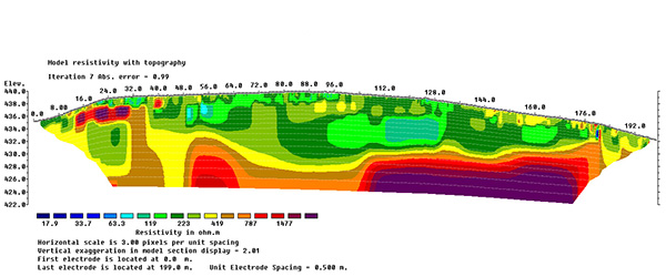
We have used the electric tomography method to study the hillfort of Villasviejas del Tamuja (Botija, in the province of Cáceres, Spain). The work plan carried out in Villasviejas had two objectives: on the one hand, it was proposed to create long profiles that crossed both enclosures longitudinally and transversely, with the intention of assessing the stratigraphic deep and the relationship between the archaeological deposits and the geological base. On the other hand, pseudo-3D studies were considered, consisting of data collection with a grid composed of parallel profiles spaced 0.5 m, with an electrode interval of 0.5 m. This type of register adds a horizontal reading to the previous one that makes it possible to appreciate the layout of the buried structures. We have identified important anomalies that present a clear correlation with the results obtained by other geophysical methods that have been applied.
2019 Synthetic PGV and IMM values for the 28 February 1969 (M = 8) Cape St. Vincent earthquake
Pro, C.; Buforn, E.; Udías, A.; Borges, J. F.; Sousa-Oliveira, C. Synthetic PGV and IMM Values for the 28 February 1969 (M = 8) Cape St. Vincent Earthquake; Madrid, 2019.
The study of the rupture process for the 28 February 1969 (Mw = 7.8) Cape St. Vincent earthquake is limited due to the characteristics of seismic data, analogical records that were generally saturated, and to the lack of other large earthquakes in this region recorded by broad band instruments. This lack of information may be solved using the results of focal mechanism obtained using high quality data for the 2007 (Mw=6.1) and 2009 (Mw=5.5) earthquakes with epicentres close to the 1969 event. As a first step, we have checked a 3D crustal model for this region generating synthetic seismograms at regional distances. We have observed a difference in the theoretical and observed arrival times that increases with the epicentral distance. On the other hand we have found a good fit between the synthetic and observed PGV values for 2007 (rms 0.06 cm/s) and 2009 (rms 0.09 cm/s) earthquakes. In addition, we have obtained an empirical relation for instrumental intensity versus PGV observed values.
These results have been used to generate the synthetic accelerations for a station located at the cable anchorage block of the suspended 25 April Bridge in Lisbon to compare with the strong motion record of the 1969 earthquake. The observed and synthetic PGA for vertical component are 1.8 and 2.6 cm/s2 respectively. Finally, we have obtained the synthetic PGV and IMM values for the 1969 earthquake and carried out the comparison with the observed intensity map.

2019 Proposal of virtual documentation and dissemination of the information of the archaeological object
Polo, M.-E.; Soto, M. de los R.; Durán-Domínguez, G.; Morán, C. J. Proposal of Virtual Documentation and Dissemination of the Information of the Archaeological Object; Vienna, Austria, 2019.
2018 Rollout archaeological photography for the graphic documentation of cultural heritage
Felicisimo, A. M.; Polo, M.-E.; Tortosa, T.; Rodero, A. Rollout Archaeological Photography for the Graphic Documentation of Cultural Heritage; Vienna, Austria, 2019.
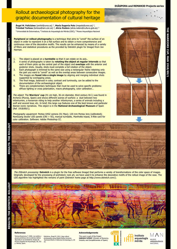
Peripheral or rollout photography is a non-destructive technique that aims to “unroll” the surface of an object in order to represent it on a flat surface and to obtain a more comprehensive and continuous view of the object’s decorative motifs. This technique is especially useful when applied to cylindrical objects. Rollout photography was developed in the mid-twentieth century and was further developed in 1970 when Justin Kerr made a series of hundreds of rollouts of Mayan vessels that can be seen in http://www.mayavase.com/. Recently, this process has been simplified with the advent of digital photography. Currently, it is possible not only to use conventional cameras but also to work with filters and digital treatments that go beyond the traditional photo. Digital rollout image in archaeology offers the opportunity to completely visualize decoration, thereby providing detailed analysis and documentation by allowing the integration of iconographic content of three-dimensional structures with decorations in all sides, shown by the same two-dimensional aesthetic narration. This poster will present the methodology necessary to obtain high-resolution rollout images considering all technical aspects from the photo shoot to digital processing. In addition to highlighting issues that have not always been accurately addressed, such as colour calibration, we will show our own development techniques to merge and “unwind” the images. Finally, we will explain how the application of specific filters (e.g., DStretch) can reveal aspects of decoration that are not clearly visible in the conventional image, improving its documentation and thus providing a thorough reading for the study of these collections.
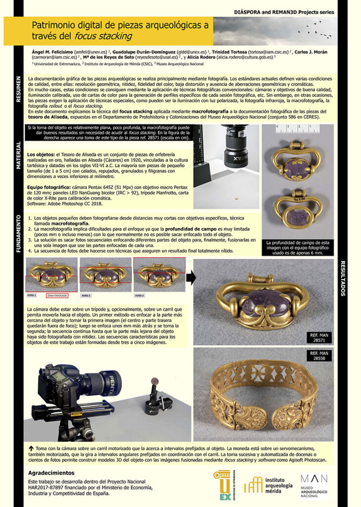
2018 Patrimonio digital de piezas arqueológicas a través del focus stacking
Felicisimo, A. M.; Durán-Domínguez, G.; Tortosa, T.; Morán, C. J.; Soto, M. de los R.; Rodero, A. Patrimonio Digital de Piezas Arqueológicas a Través Del Focus Stacking; Legatum 2.0 II Congreso Internacional de Musealización y Puesta en Valor del Patrimonio Cultural; Daimiel, 2018.
2018 Representación tridimensional de objetos arqueológicos. Una propuesta de arqueología virtual
Felicisimo, A. M.; Durán-Domínguez, G.; Tortosa, T.; Morán, C. J.; Soto, M. de los R.; Polo, M. E. Representación Tridimensional de Objetos Arqueológicos. Una Propuesta de Arqueología Virtual; Legatum 2.0 II Congreso Internacional de Musealización y Puesta en Valor del Patrimonio Cultural; Daimiel, 2018.
2018 Arqueología extremeña fuera de Extremadura; biografías de unos objetos viajeros
Tortosa, T.; Felicisimo, A. M.; Durán, G.; Morán, C. J.; Polo, M. E.; Soto, M. de los R. Arqueología extremeña fuera de Extremadura; Biografías de unos objetos viajeros; X Encuentro de Arqueología del Suroeste Peninsular, Zafra, 2018.
2006 Wind as a long distance dispersal vehicle in the Southern Hemisphere
Muñoz, J.; Felicísimo, A. M. Wind as a Long Distance Dispersal Vehicle in the Southern Hemisphere. In XVII International Botanical Congress Abstracts; Vienna, 2006; Vol. XVII International Botanical Congress Abstracts, p 74.
2006 Data Mining techniques in predictive modeling
Gómez-Muñoz, A.; Felicísimo, Á.; Muñoz, J. Data Mining Techniques in Predictive Modeling; Guerrero-Bote, V. P., Ed.; 2006; pp 37–41.
2005 Optimum digital surfaces models generated by automatic stereo-matching of convergent image networks
García-León, J.; Felicísimo, A. M.; Martínez, J. J. Optimum Digital Surfaces Models Generated by Automatic Stereo-Matching of Convergent Image Networks. In 6th Geomatic Week Proceedings; Barcelona, 2005; Vol. 6th Geomatic Week Proceedings (ISSN 1699-3489), contrib. F14, p 10.
2005 A study of ASTER DEM accuracy and its dependence on software processing
Cuartero, A.; Quirós, E.; Felicísimo, A. M. A Study of ASTER DEM Accuracy and Its Dependence on Software Processing. In Geomorphology in regions of environmental contrasts. Abstracts Volume; Zaragoza, 2005; Vol. Geomorphology in regions of environmental contrasts. Abstracts Volume, p 382.